(Back to Contents) (Stories) (Home)
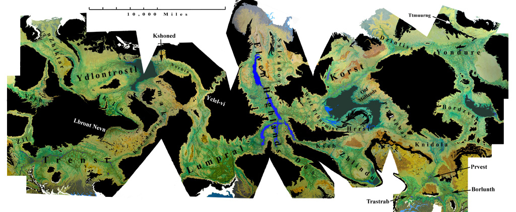
This map gives one an general idea of where the basins are and the relative size of each of them, with the caveat that many places suffer from the ‘Greenland’ effect. Basins near the poles such as Dzintiss and Tthmuurng are shown quite a bit bigger than they really are, places near the equator such as the Highlands, Bordzvek and especially Vesh are compressed somewhat smaller than they really are. Where possible the distortion has been taken up in uninhabited areas like the Ttharmine and the Great Silenius Waste (The black area that resembles a rapper with a skinny goatee and a huge ‘fro), although Dzintiss has been stretched a lot to keep that area’s distortion from becoming extreme.
No standard projection is used for this map, imagine the skin of an orange cut off in one piece and squashed flat. There is no standard distortion in any one area. The skin is torn in areas, wider towards the poles, to cut down on the Mercator distortion as much as possible. There is some overlap at the ends, the northeast meets the northwest, the southeast meets the southwest.
Clicking on the map brings you to the detailed map for the closest inhabited area. The named basins each have a map, except the Borlunth, Prvest and Trastrab basins are on the same map, Dzintiss and Tthmuurng are together, as well as Norbin and Kshoned. The Old Lands, Uttermost West and Darseen Basins make up the West Tthamine map. Platicivetre and Traguzar basins are on the Bordzvek map, The Plecerveet, Passar, Aurailia and Edniktar basin are on the Kln map and the Tduun is with the Zhlindu. For those who think of them as separate basins, the Gengee, New Midlands, Westlands, Northlands and Cutaiaa are on the Highlands map, the Darssar, Goblin and Sith basins are shown on the Korst.
The landforms of the planet are a modified plate tectonic structure but with more of the energy coming from tidal heating than radioactive decay. The preponderance of lighter materials has led to thicker continental plateaus and greater surface relief than Earth or Venus. The surface is prone to more frequent but less violent quakes than Earth. Equatorial zones have much more volcanism than higher latitudes.
The polar regions are generally lower in altitude except for the tops of the icecaps themselves which range up to twenty miles thick. The record suggests that human activity has made the atmosphere more moist then in the past and the icecaps have grown. There were three more oceans on the planet in historic times that have since all but disappeared and the Ttharmine, the largest ocean, has gone down 1700 feet and the Bordzvek ocean by over 200 feet. At least a third of this water has gone to the polar caps, most is in the ground, especially under the land of the Highland Elves, and at least 10% is in the lake.
On a world with this structure, there is no global sea level. In ancient times it was quite difficult to accurately determine the heights of different watersheds, so barometric altitude is commonly used with 0 being the surface of the Toumdaa river in the Lumpral basin, the lowest known point until modern times. Since satellite measurements have been taken it has been found that there are significant lower patches on the Borlunth/Trastrab polar plains, up to 140 feet lower. The level of the Toumba in the Earth year 3911 is now taken as zero. The river has risen twenty one inches since then due to increased polar runoff, flooding two hundred thousand acres.
Rivers can flow for much greater distances on a world without a global sea and the Karedarzin is now judged to be 19,380 miles in length till it flows out to the edge of the ice beyond Trastrab. This makes it almost ten thousand miles longer than the longest flowing river on any other planet, the Navorken of Centorin. The Karedarzin is in use for transportation for over nineteen thousand miles. The last couple hundred miles over the polar plains are uninteresting. There are several other rivers in use for transportation over ten thousand miles in length.
Not very many rivers have flowed free on the planet during recorded history. There is good evidence that the civilization that brought humans had also made major excavations. There is good evidence that even the Karedarzin, which humans regarded as a natural river, had been diverted almost half a million years in the past around the whole Illygio valley. The Karedarzin used to flow down the Illygi making it only half as long. There is also evidence that it was diverted just south of Zil and once flowed into the Bordzvek ocean, and the whole Miassa was once a lake, caused by that diversion when the channel was blasted thru the Fronzhorps in the Saggothan Age.
Humans work to get the water into the soil and forbid it to flow downstream wherever they can. The planet has never been as dry as Kinunde, but the amount of moist, fertile land seems to have doubled in historic times. The result has been dried out oceans. There were five in historical times, as many as seven prehistoric, at least six. It is possible the Lumpral and Borlunth polar oceans were one, and the Icecap was considerably smaller in those times. There are ancient beaches three thousand feet above the current water level, inundating a million squares miles of the Lumpral basin and three or four million square miles of tundra.
The basins are taken from the Kassikan standard catalog. There are many who claim many of these basins should be combined. This is the most complete list except for many extremists who want to further subdivide many of these. The populations are from the most recent reliable estimates, in some cases before first contact.
| Basin | Population in millions | ||
|---|---|---|---|
| Square Miles | Square Km | ||
| The Highlands | 14,425,000 | 37,359,000 | 4,335 |
| Gengee | 1,325,000 | 2,590,000 | 193 |
| Salvador | 6,710,000 | 17,378,000 | 769 |
| New Midlands | 1,885,000 | 4,882,000 | 911 |
| Dos | 5,790,000 | 15,461,000 | 1,145 |
| Kyeb | 2,225,000 | 5,762,000 | 1,015 |
| Uttermost West | 3,015,000 | 7,808,000 | 810 |
| Darceen | 438,000 | 1,134,000 | 407 |
| Old Lands | 1,255,000 | 3,250,000 | 675 |
| Korst | 10,175,000 | 26,351,000 | 1,323 |
| Old Midlands | 3,105,000 | 8,041,000 | 535 |
| Hrrst | 2,715,000 | 7,031,000 | 1,565 |
| Zhlindu | 4,060,000 | 10,515,000 | 1,285 |
| Tduun | 1,115,000 | 2,888,000 | 460 |
| Dzintiss | 3,100,000 | 8,028,000 | 390 |
| Pewpspway | 4,005,000 | 10,372,000 | 466 |
| Trastrab | 2,014,000 | 5,216,000 | 223 |
| Knidola | 3,401,000 | 8,808,000 | 420 |
| Prvest | 1,600,000 | 4,144,000 | 405 |
| Tthmuurng | 678,000 | 1,756,000 | 99 |
| Yondure | 8,720,000 | 22,583,000 | 4,310 |
| Bordzvek | 3,700,000 | 9,582,000 | 1,445 |
| Platicivetri | 1,205,000 | 3,120,000 | 435 |
| Traguzar | 1,575,000 | 4,079,000 | 175 |
| Borlunth | 1,880,000 | 4,869,000 | 950 |
| nZhiktar | 5,780,000 | 14,969,000 | 536 |
| Vesh (Sunhillow) | 4,050,000 | 10,488,000 | 638 |
| Zil | 2,475,000 | 6,410,000 | 1,020 |
| Trenst | 14,400,000 | 37,294,000 | 4,273 |
| Ydlontrostl | 8,510,000 | 22,040,000 | 1,915 |
| Edniktar | 1,115,000 | 2,888,000 | 313 |
| Passar | 511,000 | 1,323,000 | 94 |
| Kln | 375,000 | 971,000 | 120 |
| Plecerveet | 510,000 | 1,320,000 | 193 |
| Auraila | 1,375,000 | 3,561,000 | 187 |
| Lbront Nevn | 1,950,000 | 5,050,000 | 288 |
| Norbin | 1,015,000 | 2,629,000 | 583 |
| Kshoned | 915,000 | 2,370,000 | 437 |
| Fmak | 4,445,000 | 11,512,000 | 738 |
| Karedarzin | 1,675,000 | 4,337,000 | 497 |
| Yclel-Vi | 2,105,000 | 5,452,000 | 812 |
| Lumpral | 12,320,000 | 31,907,000 | 4,270 |
The total land in this does not agree with the generally accepted figure of 117,000,000 square miles of habitable land. This is because the figures in the table include large tracts of desert and tundra that is explorable, but not really habitable. Currently about 45,000,000 square miles of the planet is 'inhabited' in that is is modified in some way by human activity. Another 50,000,000 square miles is 'frequented' by some form of humans in a hunter-gatherer lifestyle. The number of people living in hunter-gatherer conditions is less than one hundred million at any one time. They are most frequent in the Knidola, Fmak and Ydlontrostl basins.
The largest cities using the latest reliable estimates of population. In many cases that is the same count as given at first contact.
| City | population in millions |
Litteral translation (*=not named in Kassidorian) |
|---|---|---|
| KassidorYakhan | 103.2 | All of Land Main Hub |
| Trenst | 100-200 | Super swampy |
| Yondure | 91.1 | Microchloric* Great Castle - Lystic |
| Lumpral | 73.0 | Walk Elastic* Known World - Mythra |
| Lasnar | 71.1 | Sand by the Channel |
| Bordzvek | 69.7 | Bordz mouth. (The Bordz is a river) |
| Darceen | 60.3 | Sunken Garden |
| Zhlindu | 57.9 | Jagged Jungle |
| Hrrst | 57.0 | Angriest* Sucking Mud - Goblin |
| Hb’Nah | 55.0 | ??* Sneeze - pre-Megnish |
| Dzintiss | 54.1 | ??* Empire city - Zhock |
| Korsto | 54.1 | The Korst |
| Lbront Nevn | 52.0 | ??* Emperor’s Grounds - Lobth |
| Kshoned | 51.6 | Small and Valuable* - Original meaning and language lost |
| Platicivetrie | 50.3 | ??* - Original meaning and language lost |
| Dos | 48.7 | Lock (as in canal) |
| nZhiktar | 46.1 | Town of polite surprise* Dead Winter - Lystic |
| Yclel-vi | 45.7 | Sleeper on Crooked River |
| Oterlaveshta | 44.6 | ??* Camp of the Uttermost Wilderness - Lystic |
| Kln | 43.5 | Bluff (geological) |
| Ydlontrostl | 39.3 | Total Freedom of the Vast Prairie |
| Plecerveet | 39.1 | Collection of Pretty Stones |
| Norbin | 38.8 | Busy Factory |
| Hyeevdon | 33.5 | Contentment of late sunset purple* Hyee’s Bridge - Old Megnish |
| Prvest | 32.7 | Birthland, home of my heart, dear motherland, etc. |
| Knidola | 31.6 | Is a came from tired* Original meaning and language lost. |
| Borlunth | 30.9 | Crude Noise* Royal Landing - Southern Polar Troll |
| Tthmuurng | 30.6 | Smallest pinnacle* Winter Home - Tundric |
| Fmaklar | 30.3 | Fmak Town (the Fmak are an ethnic group) |
| Trastrab | 29.8 | Rushing Rush (implying whitewater) |
| Kyeb | 29.2 | Quiviering* Beach - Old Southern Nordic |
| Edniktar | 28.8 | Loose Traffic Town |
(Back to Contents) (Stories) (Home)